Product features
Data accuracy and efficient data management are major common challenges for GIS. With Spectrum Spatial, it becomes easy to manage your geospatial data efficiently and accurately, all in one place.
Flexible Integration
Spectrum Spatial to combine more data with easy imports and exports for most file formats.
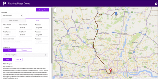
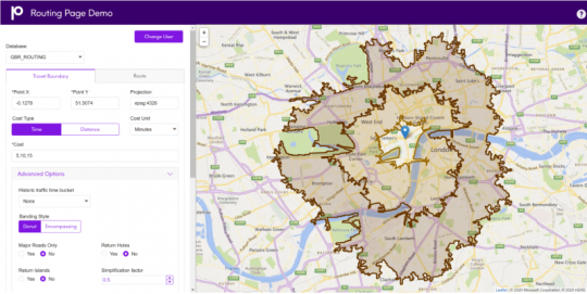
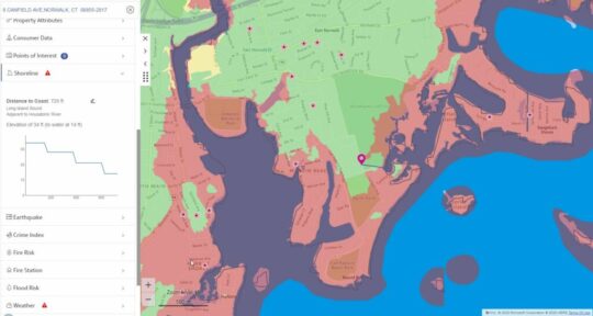
Location Intelligence
Deliver location-enabled intelligence in an understandable format for all businss roles.
Rapid Deployment
Ready to use out of the box with intuitive interfaces for GIS specialists.
High Security & Manageability
Data security, authentication, monitoring, logging, and auditing all in one place.
Flexible Integration
Easily update and visualise your maps and data on any device, wherever, whenever.
Be In Control
With Spectrum Spatial, you decide what data can be accessed, how, and who by.
FAQs
Spectrum Spatial supports various data formats and platforms, making it easy to collate everything you’ve collected into one place for easy readability. Now, you can combine information from:
-
Generic Java Database Connectivity (JDBC®)
-
Microsoft SQL Server®
-
PostgreSQL®/PostGIS
-
Oracle®
-
GeoPackage
-
and more
It’s easy for developers to add to Spectrum Spatial, building on top of the core application. In fact, Spectrum Spatial has been designed with this in mind, so you can confidently customise views, add branding, and tailor the software to the spatial insights of your business and its needs.
Spectrum Spatial makes your data easy to interpret, so anyone in your business can understand its output. However, there are four key personas that would find the software most useful on a day-to-day basis:
-
Analysts: using dashboards and mapping cisualisation to obtain key insights
-
Data administrators: understanding what data is available, and what are its variables
-
Data engineers: using spatially augmented data to make business predictions
-
Developers: creating web applications and dashboards from location intelligence APIs
Get the Most Out of Spectrum Spatial
Optimise the output of your location intelligence.
Utilise Big Data
Don’t be put off by large sets of data. Understand trends and patterns across millions of geographic data points with Spectrum Spatial, without compromising on speed or performance.
Precisely ID then has the ability to link different datasets together, even if they come from different sources, making your geospatial data more accessible than ever
Define Your Own Limits
Open architecture and vast scalability make Spectrum Spatial limitless. With this software, it’s easy to create your own applications and choose the functionality of your geospatial insights.
Precisely’s SOA-compliant solution architecture sets you up to get the most out value from your location data
Fast Results
Spectrum Spatial is high powered and easy to use, making it easy to achieve fast, quality results. Create one intelligent view with this flexible and intuitive platform that functions across devices, meaning more value for more users within your business.